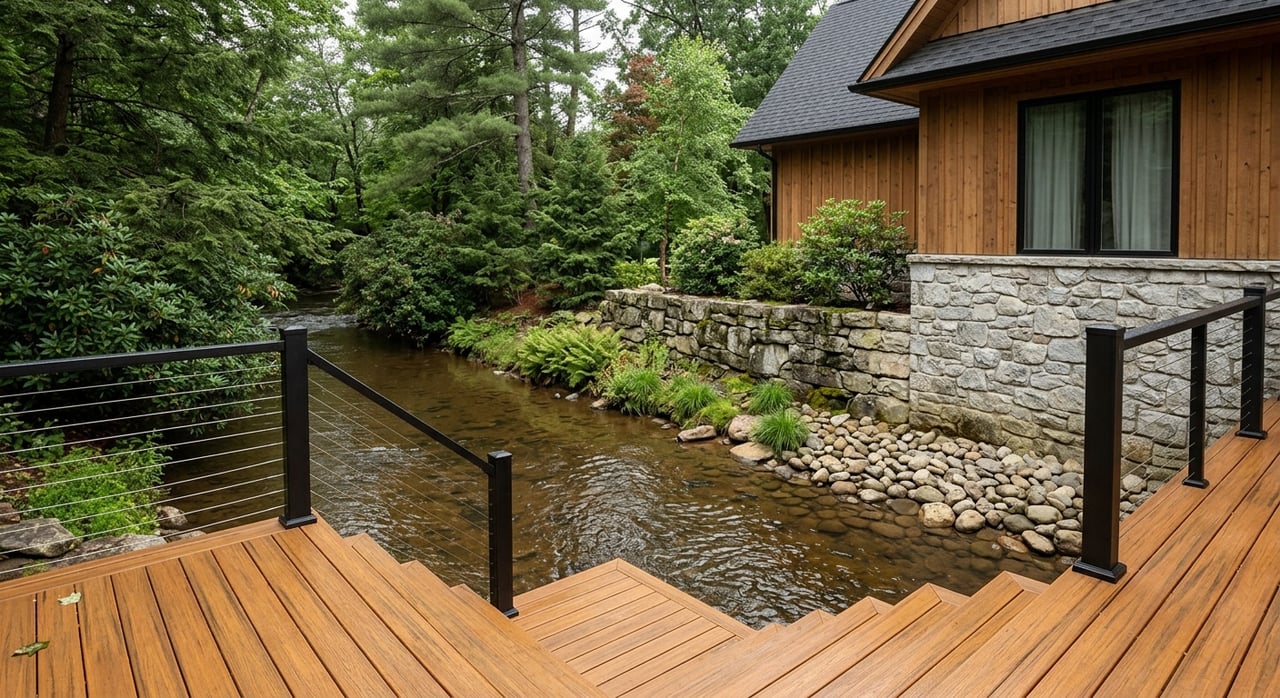
Picture this: you wake up to moving water, mist in the valley, and a quiet mountain morning that feels a world away from the rush. That is the draw of riverfront and creekside living near Andrews, and it is easy to see why buyers fall for it quickly. Still, waterfront charm comes with a few extra layers of homework, especially when flood risk, access, and property use enter the conversation. If you are thinking about buying near the Valley River or another water feature in Cherokee County, this guide will help you sort the romance from the reality. Let’s dive in.
Why Riverfront Living Appeals
Andrews sits in a valley surrounded by the foothills of the Great Smoky Mountains, and the Valley River runs through the area before joining the Hiwassee River. That geography gives many nearby properties a setting that feels scenic, peaceful, and connected to the outdoors. For many buyers, that mountain-and-water combination is the whole point.
The lifestyle appeal is not hard to understand. The town highlights unspoiled streams, rivers, mountains, and ridges, and it has also promoted amenities tied to the river, including the fishing pier at Dave Bristol Park. Town information also notes that the Valley River is stocked with rainbow trout three times a year, which adds to the area’s appeal for buyers who enjoy fishing and outdoor recreation.
For second-home buyers, full-time residents, and those looking for a mountain retreat, creekside or riverfront property can offer a quieter setting than many in-town locations. You may get the sound of water, easy access to nature, and a setting that feels distinctly Western North Carolina. It is a lovely picture, but it does call for a more careful buying process than a typical inland home.
Flood Risk Matters More Than You Think
A waterfront home does not have to sit right on the riverbank to have flood concerns. FEMA notes that flood risk can come from heavy rain, drainage problems, and nearby construction, not just from direct contact with the water. In other words, a property that looks perfectly calm during a showing may still deserve a serious flood review.
FEMA flood maps remain the official source for National Flood Insurance Program mapping, and high-risk flood areas have at least a 1% annual chance of flooding. In North Carolina, the main public tools for address-level review are the state flood portal and the FRIS tool. These resources can help you view flood maps, review property-specific flood hazards, and estimate possible flood insurance needs.
This is especially important in Andrews because flood data is not static. Cherokee County announced a public open house in 2025 to review updated flood hazard and flood risk data for unincorporated Cherokee County and the Town of Andrews. That is a helpful reminder that flood status should be checked again during due diligence, even if an older listing description or previous owner suggested everything was fine.
Local Rules Shape What You Can Do
The Town of Andrews has a Flood Damage Prevention Ordinance for flood-prone areas. The ordinance is designed to reduce property loss and safety risks and addresses uses that may be dangerous because of water or erosion hazards. It also regulates changes to floodplains and stream channels, along with filling, grading, dredging, and other development activity that could increase erosion or flood damage.
That matters if you are dreaming of adding a driveway, moving earth, expanding a home, or making major site changes. A waterfront lot may seem simple at first glance, but the rules can be more layered than they appear. It is far better to confirm those details before you close than to discover limits after the fact.
Erosion And Bank Stability Count Too
Flooding tends to get most of the attention, but erosion deserves a seat at the table as well. According to NC DEQ, vegetated areas next to water help stabilize streambanks, absorb sediment and nutrients, control erosion, and support flood control and property protection. That means the condition of the bank and surrounding vegetation can tell you a great deal about long-term maintenance and risk.
If you are evaluating a creekside or riverfront parcel, pay attention to recent clearing, grading, or exposed banks. A pretty view is wonderful, but you also want to know whether the site appears stable. In practical terms, healthy vegetation near the water can be more than landscaping. It can be part of the property’s protection.
Check Flood Insurance Early
One of the most common surprises for waterfront buyers is insurance. FEMA states that most homeowners insurance policies do not cover flood damage, so flood insurance is generally a separate policy. If a building is in a Special Flood Hazard Area and you are using a federally backed loan, flood insurance may be required.
Timing matters too. FEMA notes that NFIP policies typically have a 30-day waiting period unless coverage is required in connection with a government-backed loan or tied to a map change. So if you are financing a riverfront purchase, this is not the sort of detail to leave until the final week.
A smart step is to ask about flood zone status and likely insurance requirements as early as possible. That can help you compare carrying costs more accurately and avoid last-minute scrambling. It is not the glamorous side of mountain living, but it is very much part of buying wisely.
Look Closely At Access
Access can be just as important as flood status. In this part of the world, some of the prettiest parcels are also the ones that raise the most questions about roads, driveways, and ease of entry. NCDOT states that anyone developing property, redeveloping property, changing use, or altering existing access to the State Highway System must obtain a driveway permit.
That review can involve design, drainage, traffic impacts, and motorist safety. NCDOT also says buyers should contact local authorities and the district engineer early, since even simple requests can take around four weeks or more. If a property’s access seems informal, steep, or unfinished, that deserves extra attention before you commit.
Utilities And Site Services Need Answers
Rural and semi-rural waterfront properties often raise utility questions quickly. Cherokee County notes that manufactured-home permit applicants must provide septic and well approval or approval to connect to town water and sewer. The county also specifically says that if a property is near rivers, lakes, streams, or creeks, applicants should contact Building Code Enforcement before applying because floodplain or watershed rules may apply.
Even if you are not buying a manufactured home, the broader lesson is clear. Waterfront location can affect how a site is reviewed and what approvals may be needed. If a parcel will need septic, a well, or connection planning, those questions should be part of your due diligence early in the process.
For broader development or nonresidential questions, the Town of Andrews advises buyers to contact Planning and Zoning before purchasing or starting a project. If you are considering changes to the site or structure, a quick conversation upfront can save you time, money, and a fair bit of muttering into your coffee later.
Use GIS As A Starting Point
Cherokee County’s GIS and interactive map viewer can be very useful when you first begin researching a property. They can help you get oriented, review parcel information, and identify potential issues worth exploring further. That said, the county also warns that GIS data may not be suitable for every purpose and should be verified before decisions are made.
For riverfront and creekside properties, that means online map review should not be the final word. It is best paired with a survey, a close review of the parcel itself, and confirmation from the floodplain administrator or a licensed surveyor when needed. If the mapped flood zone appears inconsistent with actual conditions or survey results, FEMA has a Letter of Map Change process for some situations.
Short-Term Rental Plans Need Verification
If you are buying a riverfront cabin as a second home or potential short-term rental, be sure to verify the use before closing. Cherokee County requires owners and managers of accommodations rented for fewer than 90 consecutive days to collect a 4% occupancy tax and file monthly reports. That makes compliance part of your investment analysis from day one.
Zoning matters too. The Town of Andrews says Planning and Zoning can help buyers confirm whether a property can meet the Andrews Development Ordinance. If your goal is to turn a waterfront home into an income-producing property, it is important to verify both use and practical logistics before the purchase becomes final.
A Simple Buyer Checklist
If you are considering riverfront living near Andrews, keep this short list handy during your search:
- Check the property in the North Carolina flood portal and FRIS tool
- Ask whether the home or structure is in a mapped flood hazard area
- Review likely flood insurance needs and timing early
- Look at drainage patterns, grading, and foundation condition
- Inspect streambank stability and vegetation near the water
- Confirm driveway access and whether permits may be needed
- Verify septic, well, or water and sewer options
- Contact Planning and Zoning or Building Code Enforcement when future use or development is part of the plan
- Confirm short-term rental compliance requirements if you plan to rent the property
Riverfront Living Can Be Worth It
Riverfront and creekside homes near Andrews offer a lifestyle that many buyers are actively searching for. You get mountain scenery, access to water, a strong connection to the outdoors, and the slower rhythm that draws so many people to this part of Western North Carolina. For the right buyer, it can be a fantastic fit.
The key is to buy with clear eyes. These properties often need more review around flood status, insurance, access, utilities, and permitted use than an inland home would. If you are prepared for that extra diligence, you can make a decision that feels exciting and sensible at the same time.
If you are exploring riverfront homes, creekside cabins, or mountain investment property near Andrews, I would be glad to help you sort through the details and keep the process practical. You can start the conversation with Allison Ralph.
FAQs
What makes riverfront living near Andrews appealing?
- Riverfront and creekside properties near Andrews appeal to many buyers because of the mountain setting, access to streams and rivers, fishing opportunities, and the quiet small-town atmosphere tied to the Valley River area.
How can you check flood risk for a property near Andrews?
- You can review flood risk using North Carolina’s flood portal and FRIS tool, then verify details during due diligence with a survey and, when needed, confirmation from the local floodplain administrator or a licensed surveyor.
Does a riverfront home near Andrews need flood insurance?
- A riverfront home near Andrews may need separate flood insurance because standard homeowners insurance typically does not cover flood damage, and flood insurance may be required for properties in a Special Flood Hazard Area with a federally backed loan.
What property issues should you inspect on a creekside home in Cherokee County?
- Key items to inspect include drainage, grading, foundation condition, streambank stability, vegetation near the water, access, and the feasibility of septic, well, or utility connections.
Can you use a river cabin near Andrews as a short-term rental?
- A river cabin near Andrews may be used as a short-term rental only after you verify zoning and permitted use with the Town of Andrews, and Cherokee County requires accommodations rented for fewer than 90 consecutive days to collect a 4% occupancy tax and file monthly reports.
Why should you verify driveway access on waterfront property near Andrews?
- Driveway and road access matter because NCDOT requires permits for certain access changes to the State Highway System, and permit review can involve drainage, safety, and design considerations that may affect your timeline and plans.